Countries With No Rivers in the World: Complete List of Riverless Countries Explained
A river feels like something when you think about what makes a country what it is.
People built things next to rivers. Cities grew up around rivers. Farms need rivers. Borders often followed rivers. Trade routes followed the path of rivers. From the Nile and Amazon to the Ganges, Yangtze and Mississippi rivers have helped shape the map of life.
There is a small number of countries that have no rivers at all. Not a single natural river that stays there all the time.
It feels strange because “no rivers” doesn’t always mean “no water.” Some of these countries get a lot of rain. Others have floods during certain times of the year. Some are depended over underground sources of fresh water. Several have made systems to take salt out of seawater, get water from underground, collect rainwater or reuse water they already have.
The difference matters. When experts say a country has no rivers they usually mean it has no river that flows all the time inside its borders. Some might have streams that only show up after rain or dry valleys or wadis or short channels that only carry water for a while. The old CIA World Factbook listed 21 countries without rivers. These are spread across Africa, Asia, Europe, the Americas and Oceania.
This is not really a story about countries without water. It is a story about how geography controls how water moves.
What Does It Mean for a Country to Have No River?
A river is not just water going down a slope.
For a river to be permanent, the land needs rain, a good area to collect water, the right kind of land, help from groundwater and water that keeps flowing. Rain or melting snow has to get into a channel than it goes away through evaporation or other ways.
If that balance doesn’t work the river might only be there for a while.
That is why the phrase “countries with no rivers” needs some explanation. A country might have a channel that becomes a moving stream after a storm but is empty for months or even years. In some areas, these are often called wadis.
Malta is an example. Official sources say its waterways are temporary. Heavy rain can make dry valleys flow again. The water might only be there, for a short time. Malta has no rivers or streams that flow all the time.
So the real thing to look at is not whether there is water all the time. It is whether there is a river system that stays there all the time.
| Rank | Country |
|---|---|
| 1 | Saudi Arabia |
| 2 | Libya |
| 3 | Oman |
| 4 | Yemen |
| 5 | United Arab Emirates |
| 6 | Kuwait |
| 7 | Qatar |
| 8 | Djibouti |
| 9 | Bahrain |
| 10 | Maldives |
| 11 | Bahamas |
| 12 | Comoros |
| 13 | Malta |
| 14 | Marshall Islands |
| 15 | Kiribati |
| 16 | Tonga |
| 17 | Tuvalu |
| 18 | Nauru |
| 19 | Niue |
| 20 | Monaco |
| 21 | Vatican City |
How Many Countries Have No Rivers?
The answer depends slightly on the definition and source.
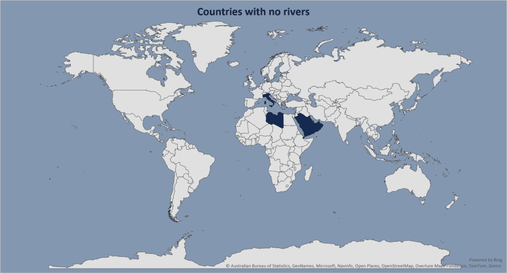
The archived CIA World Factbook identified twenty‑one countries without rivers: three in Africa, one in the America, eight in Asia, three in Europe and six in Oceania. It also stated that these countries had no lakes.
Using that definition, the countries are Comoros, Djibouti and Libya in Africa; the Bahamas in the Americas; Bahrain, Kuwait, Maldives, Oman, Qatar, Saudi Arabia, the United Arab Emirates and Yemen in Asia; Malta, Monaco and the Holy See (Vatican City) in Europe; and Kiribati, the Marshall Islands, Nauru, Niue, Tonga and Tuvalu in Oceania.
Other geographical references produce different totals because they handle seasonal streams, tiny islands and particular hydrological definitions differently. Some lists for example contain nineteen or twenty countries than twenty‑one.
For a comparison, the twenty‑one‑country CIA definition is a useful consistent baseline while acknowledging that the boundary of the category is not mathematically absolute.
The geographical pattern is fascinating
Most of these countries fall into two groups: extremely dry continental or peninsula environments and small islands or microstates. Those two landscapes arrive at the outcome by completely different routes.
The First Group: Countries Where Rain Rarely Becomes a River
The obvious cluster lies around the Arabian Peninsula. Saudi Arabia, the United Arab Emirates, Oman, Yemen, Qatar, Bahrain and Kuwait have no natural rivers. Their landscapes instead contain valleys and wadis that can carry water after rainfall.
The reason is fundamentally climatic.
Much of the region receives highly variable rainfall while temperatures and evaporation rates can be high. Rain may arrive in bursts rather than as steady precipitation spread across the year. Water therefore often disappears through infiltration or evaporation before a permanent river system can establish itself.
The result is a landscape.
A dry valley can look completely lifeless for months then suddenly become a stream after a major storm.
A wadi is therefore not necessarily a “failed river.” It is an adaptation of the drainage system to an environment where rainfall’s intermittent.
Qatar for example has hundreds of ancient dry valleys. Its government describes six hundred and fifteen dry valleys illustrating how extensive drainage channels can exist even where permanent rivers do not.
The landscape has drainage. It simply does not have a year‑round river.
Saudi Arabia: The Worlds Largest Riverless Country
Among the countries Saudi Arabia stands out because of its size.
It covers than two million square kilometres yet it has no permanent natural rivers.
That makes it one of the demonstrations that a country’s physical size does not guarantee the presence of a river.
Saudi Arabias geography is dominated by arid and hyper‑arid environments, including the Rub’ al Khali or Empty Quarter. Historical World Bank geographic documentation describes the country as having no rivers or bodies of water with rainfall highly variable and generally scarce.
Water has therefore had to come from else. Modern Saudi Arabia relies heavily on desalination, groundwater and large‑scale water infrastructure. The absence of rivers has not prevented the development of cities; instead it has forced water supply to become an engineering problem.
That is one of the recurring themes, among countries. Where nature does not provide a freshwater conveyor belt infrastructure takes over the job.
The Arabian Peninsula Is the World’s Largest Riverless Region
The striking geographical fact is not that individual countries lack rivers. It is that an entire large area does.
The Arabian Peninsula is the world’s largest subregion without permanent natural rivers. The countries of the Arabian Peninsula are instead characterized by wadis and other intermittent drainage systems.
This creates a contrast with neighbouring parts of Southwest Asia. To the north and northeast lie some of the world’s great historical river systems, particularly the Tigris and Euphrates. Ancient Mesopotamian civilization developed around rivers.
Much of the Arabian Peninsula developed under the opposite water conditions. The difference is not simply cultural. The difference is written into the climate and geology of the landscape.
Libya: A Country With No River but an Enormous Underground Water Story
Libya is another example. Libya is one of Africa’s countries yet Libya has no permanent natural river.
The reason is largely Libya’s arid environment. Much of Libya lies within the Sahara, where rainfall’s too scarce and irregular to sustain always flowing surface rivers.
Libya’s water geography has a remarkable second layer. Beneath the desert are ancient groundwater reserves accumulated over long geological periods. These underground resources became the foundation of Libya’s Great Man-Made River project, which transports old underground water through an extensive network of pipelines toward populated areas.
The name is slightly misleading. The Great Man-Made River is not a river. The Great Man-Made River is an engineered water transfer system. That distinction is worth making because the phrase “Riverless country” can hide enormous amounts of water beneath the surface.
A country can have no rivers. Still possess major groundwater resources. The problem is that groundwater does not necessarily replenish quickly. Old underground water can be effectively non-renewable on timescales. So underground water can solve a water-supply problem without solving a long-term sustainability problem.
Djibouti: Where Water Arrives in Bursts
Djibouti provides another version of the desert model.
Djibouti is small, hot and extremely arid and Djibouti lacks a river system. Seasonal watercourses can appear after rain in mountainous areas. This is a characteristic of dry landscapes.
When rain comes, rain can come quickly. Instead of producing a gentle continuously flowing river, a storm can generate sudden runoff that races through channels before disappearing into the ground or evaporating.
The absence of rivers therefore does not mean the absence of flood risk. In fact some riverless countries can experience rapid floods precisely because rainfall is concentrated into short heavy rains. The contradiction is striking: little water, for a river yet occasionally too much water to handle safely.
The Second Group: Islands That Are Simply Too Small
The other major category is totally different.
Think about countries like the Maldives, Kiribati, Tuvalu, Nauru, Tonga and the Marshall Islands
They are not riverless because they are deserts, They are riverless because of their island geography.
A river needs a drainage basin. Rain needs enough land to collect into channels and those channels need enough elevation and geological structure to stay.
On a small island there might not be enough land. And on low-lying coral islands, there might not be enough height.
When Rain falls
Some of it goes into the ground.
Some of it evaporates.
Some of it flows straight to the ocean.
There might not be a big enough area to form a permanent river.
The Maldives shows this very clearly. The Maldivian government says the islands do not have surface-water resources like rivers and streams while fresh water is mainly in shallow groundwater lenses and rainwater.
In other words the Maldives gets rain. A lot of it. That rain does not become rivers
The Maldives Shows Why “No Rivers” Does Not Mean “Dry”
This might be the biggest misunderstanding about riverless countries. The Maldives gets a lot of rain because of its monsoon climate. Yet its islands have no rivers because of their small size, low height and porous rocks
Instead rainwater goes into the ground and makes thin layers of fresh water floating above seawater in the island aquifers
That makes a different kind of fresh water system than a river basin. It is delicate. If too much groundwater is taken out, saltwater can come in. If sea levels go up or storms flood islands, fresh water layers can get polluted. If rain patterns become uncertain storing rainwater becomes harder
The Maldives therefore shows an important thing about geography. A country can have lots of rain and still have very little fresh water that can be used. Water availability depends not only on how much falls from the sky but also on what happens after that.
Malta: No Rivers in the Middle of the Mediterranean
Malta is one of Europe’s most special riverless countries.
At first it seems strange. This is not a desert country in the Arabian Peninsula. It is in the Mediterranean. Has rain in the winter. Malta has no natural rivers or streams that last.
Its small size, rock type and semi-arid Mediterranean climate mean that there is not much water, on the surface
Malta’s Energy and Water Agency says the small size of the islands makes it hard to create surface-water resources that worth the cost. Government flood guidance says its dry valleys can carry water from storms but they do not act as real rivers. Instead Malta has used groundwater for a long time.
Today, desalination, using treated water again, collecting rainwater and managing groundwater all help with the Malta’s water system.
Malta is a good example of how modern technology can help with special natural conditions.
The Tiny European States
Monaco and Vatican City are listed as riverless because of their small size.
Vatican City is a microstate that occupies only a tiny area within Rome. There is simply no natural drainage basin enough to support a permanent river. Monaco is similarly tiny and highly urbanized, squeezed between the Mediterranean Sea and France.
These cases are very different from Saudi Arabia, which is a large country. Saudi Arabia is riverless even though it covers a large territory.
Vatican City is riverless partly because there is no territory where a river could exist. That is why the phrase “countries with no rivers” should never be treated as one geographical phenomenon.
The same outcome can be produced by different physical conditions.
Oceania Contains a Remarkable Concentration of Riverless States
Several of the world’s Riverless countries are scattered across the Pacific Ocean. Kiribati, the Marshall Islands, Nauru, Niue, Tonga and Tuvalu appear in the CIA’s 21‑country classification.
Many of these are composed of islands or atolls.
An atoll is especially hostile to the development of rivers. It is low, narrow and largely made of coral. There is generally elevation difference where a river could create a persistent channel.
Rainwater instead seeps through material while freshwater can build up underground in thin lenses. The result is a landscape where freshwater exists. Not as a river.
Because these islands are low‑lying, their freshwater systems can be especially vulnerable to saltwater intrusion and changes in rainfall.
For island states, the challenge is therefore not merely finding water. It is keeping freshwater fresh.
The Bahamas demonstrates another version of the island model.
The country consists of an archipelago of low‑lying islands and cays. Its geology and terrain do not provide the elevation or sustained surface runoff needed to create permanent rivers.
Rainwater can seep through limestone feeding groundwater systems rather than collecting into large permanent channels.
This is one reason the map of rivers shows a conspicuous blank space across many small island states. A river is fundamentally a landscape phenomenon. No large landscape, no permanent river.
How Do Countries Without Rivers Get Their Water?
The lack of rivers compels countries to create new and different water systems to rely on. The main sources are groundwater, rainwater harvesting, desalination, water recycling and in some places water that is brought in from elsewhere.
The exact mix varies a lot.
Desalination is very important in Gulf states because seawater is plentiful even when fresh water is scarce.
Groundwater is crucial in dry and island areas.
Rainwater harvesting is especially vital on islands.
Water reuse is becoming more important where normal fresh water is limited.
The Maldives for example uses rainwater, groundwater and desalinated seawater. Desalination is playing a role in providing drinkable water.
Malta also uses desalination, treated water reuse as part of its water‑security plan.
The irony is that some of the world’s advanced water systems exist in places where nature gives very little surface water.
The Important Comparison: Riverless Does Not Mean Waterless
Maps of the world often lead to a wrong idea. Blue lines look like plenty of water. No blue lines look like water shortage.
Reality is more complex.
The Maldives has no rivers but gets a lot of rain.
Malta has no rivers but has groundwater and it uses desalination and water reuse.
Saudi Arabia has no rivers but has big desalination plants and groundwater resources.
Libya has no natural river but has huge fossil groundwater reserves.
Small Pacific islands can have rainwater and fresh water lenses even though they have no surface rivers.
So a river is one piece of the world water puzzle. It shows how water moves across the surface.
It does not show everything about how water exists, where it is stored or whether people can reliably get it.
Conclusion: The World’s Riverless Countries Reveal the Hidden Geography of Water
There are 21 countries in the CIA’s archived list that have no permanent natural rivers. They are in Africa, Asia, Europe, the Americas and Oceania.
They do not share any common environmental factor.
Some are among the world’s driest places.
Others are islands surrounded by huge amounts of seawater but have very little usable fresh water.
Some have wadis.
Some have short‑lived streams.
Some depend on aquifers.
Others increasingly rely on desalination, rainwater harvesting and water recycling.
Their common feature is that no permanent natural river crosses their land.
That small geographic fact tells a story.
Rivers are not just lines on maps. They are made by climate, geology, elevation, drainage and time. When those ingredients do not line up, rivers vanish—even when water is still there.
That is why the world’s riverless countries are so fascinating. They remind us that water geography is much bigger than rivers.
A country can be surrounded by ocean. Still struggle for fresh water.
It can get rain and still have no river.
It can sit above an aquifer and still face long‑term water insecurity.
Blue lines on a map show the water we can see. Much of the story happens underground, in clouds, beneath porous islands, through pipelines and inside desalination plants.
In the world’s riverless countries, that hidden geography is what keeps civilization running.
Subscribe to our $1 newsletter to get new Data and Maps from around the world on various different topics every month. Click here now to join.